โš“ A Coaching Legacy Since 1984
RCI Marine Blog

Chief Mate Function 1 Oral Questions (2026): Complete MMD Navigation Oral Guide

By Deepak Gupta | Senior Mariner | Maritime Educator Rashmi Coaching Institute (RCI)

26 Jul 2026 ยท ๐Ÿ‘ 245 views ยท ๐Ÿ’ฌ 0 comments

Chief Mate Function 1 Oral Questions (2026): Complete MMD Navigation Oral Guide

Chief Mate Function 1 Oral Questions (2026): The Complete Guide to the MMD Oral Examination

  1. Every Second Officerand many ambitious Third Officers—preparing for the Chief Mate Certificate of Competency (CoC) eventually reaches one of the most challenging stages of the certification process: the Chief Mate MMD Oral Examination.
  2. Unlike a written examination, the oral examination is not designed to assess how well you can memorise regulations. Instead, it evaluates whether you can apply your knowledge in practical shipboard situations, make safe decisions under pressure, communicate professionally, and demonstrate the leadership expected of a Chief Mate.
  3. During the examination, the MMD surveyor is assessing far more than technical knowledge. They want to know whether you can think logically, analyse a situation, prioritise safety, comply with international regulations, and assist the Master in making sound navigational decisions.
  4. Many candidates possess an excellent theoretical understanding of navigation and maritime regulations. However, they lose confidence during the oral examination because they struggle to explain why they would take a particular action in a real-life situation. That is often the difference between simply knowing a regulation and demonstrating genuine professional competence.
  5. This guide has been written to bridge that gap.
  6. Rather than presenting a collection of memorised answers, this article focuses on the competencies commonly assessed during the Chief Mate Function 1 Oral Examination. It includes original practice questions, practical onboard scenarios, and examiner expectations based on the competency standards of the STCW Convention, relevant IMO regulations, and accepted professional seamanship. It does not reproduce confidential examination material or copyrighted question banks.
  7. Whether you are appearing for your first attempt or returning after a previous attempt, this guide is designed to help you develop the technical knowledge, confidence, and professional mindset expected of a future Chief Mate.

What You Will Learn in This Guide

  1. By the end of this article, you will:
  2. Understand how the Chief Mate Function 1 Oral Examination is conducted.
  3. Learn what MMD surveyors generally assess during Function 1.
  4. Practise more than 40 original Function 1 oral questions based on STCW competencies and practical shipboard operations.
  5. Understand the common mistakes that reduce candidates' marks.
  6. Learn a structured approach to answering oral questions confidently.
  7. Develop the decision-making skills expected of a Chief Mate during bridge operations.

What Is the Chief Mate Function 1 Oral Examination?

Function 1 of the Chief Mate Oral Examination focuses on Navigation at the Management Level. Unlike the written examination, there are no fixed questions or model answers. Instead, the surveyor evaluates your technical competence, practical judgement, leadership, communication skills, and ability to apply international regulations in realistic navigational situations.

Throughout the examination, candidates are expected to demonstrate that they can apply good seamanship, company procedures, Bridge Resource Management (BRM), and international conventions while maintaining the highest standards of safety for the ship, its crew, cargo, and the marine environment.

The surveyor expects you to think like a future Master, not simply answer like a student.

FUNCTION - 1 NAVIGATION

  1. Function 1 evaluates your ability to safely plan, conduct, and monitor a voyage while supporting the Master in all navigational aspects of ship operations.
  2. The examination typically assesses your ability to:
  3. Plan, execute, and monitor a safe voyage from berth to berth.
  4. Apply the International Regulations for Preventing Collisions at Sea (COLREGs) in practical situations.
  5. Use Radar, ARPA, ECDIS, AIS, GPS, and other bridge equipment effectively.
  6. Assist the Master in command decision-making during normal operations and navigational emergencies.
  7. Demonstrate effective Bridge Resource Management (BRM) and teamwork.
  8. Understand meteorology, including the interpretation of synoptic weather charts, weather forecasts, and navigational weather warnings.
  9. Demonstrate knowledge of Tropical Revolving Storms (TRS), storm avoidance, and heavy weather navigation.
  10. Explain the errors, limitations, and operational use of bridge equipment, including Radar, ARPA, ECDIS, GPS, AIS, Gyro Compass, Magnetic Compass, Echo Sounder, Speed Log, and GNSS.
  11. Respond effectively to navigational emergencies such as restricted visibility, steering failure, gyro failure, GPS failure, ECDIS malfunction, and man overboard situations.
  12. Demonstrate sound judgement and decision-making while maintaining a safe navigational watch in accordance with the STCW Code.

What MMD Surveyors Actually Assess During Function 1

One of the biggest misconceptions among candidates is that success in the oral examination depends on memorising regulations. In reality, experienced MMD surveyors assess whether you can think and act like a professional Chief Mate.

During the examination, they generally evaluate the following areas.
  1. Practical Application
  2. Can you apply international regulations and company procedures in real onboard situations rather than simply quoting them?
  3. Decision-Making
  4. Can you identify hazards, assess risks, evaluate available options, and make safe navigaktional decisions under pressure?
  5. Bridge Resource Management
  6. Can you communicate effectively with the Master, Pilot, Engine Room, lookout, and bridge team while maintaining situational awareness?
  7. Communication Skills
  8. Can you explain your decisions clearly, confidently, and professionally using proper maritime terminology?
  9. Leadership
  10. Can you organise the bridge team, allocate duties, monitor performance, and intervene when necessary to maintain safe navigation?
  11. Safety Culture
  12. Do your answers consistently demonstrate that the safety of life, the ship, cargo, and the marine environment is always your highest priority?

ENROLL NOW BY CLICKING HERE

RCI Exam Tip

The strongest candidates do not simply quote regulations—they explain how they would apply them on board. Whenever possible, structure your answer by describing the situation, identifying the hazards, explaining your immediate actions, referring to the relevant regulations where appropriate, and concluding with follow-up actions such as monitoring, reporting, and documentation. This approach demonstrates sound professional judgement and reflects the competence expected of a future Chief Mate.


How MMD Surveyors Conduct the Chief Mate Function 1 Oral Examination

One of the most common questions candidates ask before appearing for the Chief Mate Function 1 Oral Examination is:

"What exactly happens inside the examination room?"

Although every MMD surveyor has their own style of conducting the examination, the overall objective remains the same—to assess whether the candidate possesses the knowledge, judgement, leadership, and confidence expected of a Chief Mate serving at the management level.

The oral examination is not intended to test rote memorisation. Instead, it is a professional discussion in which the surveyor evaluates your ability to apply theoretical knowledge to practical shipboard situations.

Many candidates enter the examination expecting direct questions such as:

"What is Rule 19?"

or

"Define squat."

However, experienced surveyors often prefer practical scenarios that require analysis and decision-making rather than textbook definitions.

For example, instead of asking:

"Explain Rule 19."

A surveyor may ask:

"You are the Officer of the Watch in restricted visibility. Visibility suddenly reduces to less than half a mile, and two radar targets are approaching from different directions. Explain your actions step by step."

This type of question assesses not only your knowledge of the COLREGs but also your Bridge Resource Management, situational awareness, communication, and ability to prioritise safety.

What Makes a Good Oral Answer?

One of the biggest mistakes candidates make is answering too quickly.

A professional Chief Mate first analyses the situation before taking action.

Whenever you answer a scenario-based question, follow a logical sequence.

Step 1 – Understand the Situation

Before answering, identify:

  1. Where is the vessel?
  2. What are the prevailing weather conditions?
  3. Is the vessel in open sea, coastal waters, pilotage waters, or a Traffic Separation Scheme?
  4. Are there any immediate dangers to the vessel?
  5. Never assume facts that have not been provided by the surveyor. If additional information is required, politely ask for clarification.

Step 2 – Identify the Hazards

Every professional decision begins with hazard identification.

For example:

  1. Risk of collision
  2. Risk of grounding
  3. Heavy weather
  4. Equipment failure
  5. Restricted visibility
  6. Traffic density
  7. Machinery limitations
  8. Surveyors appreciate candidates who identify hazards before discussing solutions.

Step 3 – Explain Your Immediate Actions

Your first actions should always focus on safety.

For example:

  1. Inform the Master when required.
  2. Increase the level of situational awareness.
  3. Ensure a proper lookout.
  4. Reduce speed if appropriate.
  5. Use all available means to assess the situation.
  6. Follow company procedures.
  7. Apply the relevant international regulations.

Step 4 – Explain Your Reasoning

Do not simply list actions.

Explain why each action is necessary.

For example:

Instead of saying,

"I will reduce speed."

Explain,

"I will proceed at a safe speed to allow sufficient time to assess the developing situation, avoid close-quarters situations, and comply with the requirements of the COLREGs."

Professional reasoning demonstrates management-level competence.

Step 5 – Describe Follow-up Actions

A Chief Mate's responsibility does not end after taking immediate action.

Surveyors expect you to explain how you would:

  1. Continue monitoring the situation.
  2. Record relevant information.
  3. Inform the Master and company when required.
  4. Conduct debriefing if necessary.
  5. Prevent recurrence.

What Surveyors Like to See

Experienced surveyors generally appreciate candidates who:

  1. Think before answering.
  2. Speak calmly and confidently.
  3. Use correct maritime terminology.
  4. Demonstrate sound Bridge Resource Management.
  5. Prioritise safety over commercial considerations.
  6. Admit honestly when they are unsure rather than guessing.
  7. Remember, confidence should come from competence—not from attempting to impress the surveyor.

Common Mistakes Candidates Make

Many candidates lose marks for reasons unrelated to technical knowledge.

Some of the most common mistakes include:

  1. Quoting regulations without explaining their practical application.
  2. Answering before fully understanding the scenario.
  3. Ignoring Bridge Resource Management.
  4. Forgetting to mention communication with the Master.
  5. Depending entirely on AIS instead of using all available means.
  6. Giving textbook definitions where practical actions are expected.
  7. Guessing when unsure instead of explaining how they would verify the information.

RCI Exam Tip

Imagine that every question begins with the words: "You are the Chief Mate on board..."

This simple approach changes your mindset from that of a student recalling information to that of a management-level officer making professional decisions. Throughout the examination, demonstrate calm judgement, effective communication, and a safety-first attitude. These qualities often distinguish successful candidates from those who rely solely on memorised answers.
 

ENROLL NOW BY CLICKING HERE


Passage Planning: One of the Most Important Topics in the Chief Mate Function 1 Oral Examination

If there is one topic that every Chief Mate candidate should master before entering the oral examination room, it is Passage Planning.

An MMD surveyor may begin the examination with a simple question

However, don't be misled by the simplicity of the question.

What often follows is a detailed discussion covering chart appraisal, route planning, Under Keel Clearance (UKC), weather routing, bridge equipment, ECDIS, Bridge Resource Management (BRM), contingency planning, and decision-making during the voyage.

The surveyor is not merely assessing whether you can list the four stages of passage planning. They want to know whether you can prepare and execute a safe, practical, and efficient berth-to-berth voyage plan.

What Is Passage Planning?

Passage Planning is the systematic process of preparing, executing, and continuously monitoring a voyage to ensure the safety of the ship, its crew, cargo, and the marine environment.

A good passage plan should identify potential hazards well in advance and provide the bridge team with clear guidance throughout the voyage.

Remember:

A passage plan is a living document. It should be reviewed and amended whenever weather conditions, traffic, navigational warnings, equipment status, or operational requirements change.

The Four Stages of Passage Planning

The IMO recommends four essential stages of passage planning.

1. Appraisal

The appraisal stage involves gathering and evaluating all relevant information before planning the route.

Typical information includes:

  1. Latest corrected paper charts or updated ECDIS.
  2. Notices to Mariners.
  3. Sailing Directions.
  4. Admiralty List of Radio Signals.
  5. Tide Tables.
  6. List of Lights.
  7. Weather forecasts.
  8. Synoptic weather charts.
  9. Tropical Revolving Storm (TRS) warnings.
  10. NAVAREA warnings.
  11. Port information.
  12. Company navigation procedures.
  13. Vessel's draught, air draught, manoeuvring characteristics, and equipment limitations.
  14.  

Surveyors often ask:

"Which publication would you consult if you require information about pilot boarding arrangements?"

Questions like this test not only your knowledge of publications but also your understanding of where to find reliable navigational information.

2. Planning

Once all information has been collected, the route is planned in detail.

During this stage, the navigating officer should determine:

  1. Wheel-over positions.
  2. Alteration of course positions.
  3. No-Go Areas.
  4. Clearing bearings.
  5. Parallel Indexes.
  6. Under Keel Clearance.
  7. Safe speed in restricted waters.
  8. Traffic Separation Schemes.
  9. Reporting points.
  10. Pilot boarding position.
  11. Contingency anchorages.
  12. Abort points.
  13. Position-fixing intervals.
  14. Bridge manning requirements.

Surveyors frequently ask:

"How do you decide the width of a No-Go Area?"

They expect candidates to discuss chart accuracy, UKC, squat, vessel dimensions, environmental conditions, safety margins, and company procedures rather than giving a fixed distance.

3. Execution

The execution stage begins when the vessel sails.

During execution:

  1. The Master confirms the passage plan.
  2. The bridge team is briefed.
  3. Pilot exchange of information is completed.
  4. Navigation follows the approved passage plan unless safety requires a deviation.
  5. Weather and traffic conditions are continuously monitored.
  6. The surveyor may ask:
  7. "When would you deviate from your approved passage plan?"

A professional answer should include examples such as avoiding severe weather, responding to traffic situations, complying with VTS instructions, or addressing equipment failures—provided any deviation is safe, justified, and communicated in accordance with company procedures.

4. Monitoring

Monitoring continues throughout the voyage.

The Officer of the Watch should continuously verify that the vessel remains safely on the planned track.

Monitoring includes:

  1. Frequent position fixing.
  2. Cross-checking GPS with independent methods where appropriate.
  3. Radar parallel indexing.
  4. Echo sounder monitoring in shallow waters.
  5. Compass error checks.
  6. Weather monitoring.
  7. Traffic assessment.
  8. ECDIS route monitoring.
  9. Continuous Bridge Resource Management.

Surveyors often ask:

"How do you verify that GPS is giving the correct position?"

This is a practical question. They expect you to explain cross-checking by visual bearings, radar ranges, transit bearings, celestial observations where applicable, echo sounder trends, and other independent means available on board.

Original Oral Practice Questions – Passage Planning

Question 1

Explain the four stages of passage planning.

What the surveyor is assessing:

  1. Understanding of the complete planning process.
  2. Practical application rather than memorised definitions.
  3. Ability to explain each stage clearly.

Question 2

What publications would you consult before preparing a passage plan?

Possible follow-up questions:

  1. Which publication contains radio reporting procedures?
  2. Where will you find information regarding pilot boarding arrangements?
  3. Which publication provides information on traffic routing systems?
  4. How do you ensure your charts and publications are fully corrected?

Question 3

How do you determine Under Keel Clearance (UKC) for a coastal passage?

Surveyors expect you to discuss:

  1. Charted depth.
  2. Height of tide.
  3. Static and dynamic draught.
  4. Squat.
  5. Heel and trim.
  6. Wave response.
  7. Company UKC policy.
  8. Local port requirements.

RCI Exam Tip

When answering passage planning questions, don't stop after naming the four stages. Demonstrate how you apply them on board using real examples from your sea service. Surveyors are looking for evidence that you can translate theory into safe navigation.
 

ENROLL NOW BY CLICKING HERE


COLREGs: How MMD Surveyors Test Your Decision-Making

The International Regulations for Preventing Collisions at Sea (COLREGs) form the foundation of safe navigation. During the Chief Mate Function 1 Oral Examination, MMD surveyors rarely expect candidates to recite rules word for word. Instead, they assess whether you can correctly identify a developing situation, determine the applicable rule, evaluate the risk of collision, and take timely, positive action to avoid an accident.

One of the biggest misconceptions among candidates is that remembering rule numbers is enough. In reality, surveyors are much more interested in how you think than what you memorise.

For example, instead of asking:

"Explain the crossing situation between two power-driven vessels."

An MMD surveyor is more likely to present a practical scenario such as:

"You are the Officer of the Watch on a vessel making 14 knots. Another power-driven vessel is approaching from your starboard side with a constant bearing and decreasing range. Explain your actions."

A professional answer should never begin by quoting a rule number.

Instead, follow this sequence:

  1. Identify the type of encounter (crossing, overtaking, head-on, restricted visibility, etc.).
  2. Assess whether a risk of collision exists using all available means.
  3. Identify the applicable COLREG Rule only after you have correctly identified the situation.
  4. Explain your actions and, more importantly, the reasons behind them.
  5. Describe how you will monitor the effectiveness of your actions until the vessels are finally past and clear of each other.
  6. This structured approach reflects the way experienced Chief Mates think on the bridge and is exactly what MMD surveyors expect during the oral examination.

How to Approach Every COLREG Question

Whenever you are presented with a collision-avoidance scenario, answer it in a logical sequence.

Step 1 – Identify the Situation

Before taking any action, determine the type of encounter.

Is it:

  1. Overtaking?
  2. Head-on?
  3. Crossing?
  4. Restricted visibility?
  5. Narrow Channel?
  6. Traffic Separation Scheme?
  7. Special Circumstances?
  8. Correctly identifying the situation is the first step towards applying the correct COLREG Rule.

Step 2 – Assess the Risk of Collision

Once the situation has been identified, determine whether a risk of collision exists.

Explain how you would assess the risk using:

  1. Visual observation.
  2. Compass bearings.
  3. Radar plotting.
  4. ARPA information.
  5. CPA and TCPA.
  6. All available means appropriate to the prevailing circumstances and conditions.

Surveyors appreciate candidates who explain how they determine the risk rather than simply stating that a risk exists.

Step 3 – Identify the Applicable Rule

Only after identifying the situation and assessing the risk should you determine which COLREG Rule applies.

This demonstrates that your decision is based on a proper assessment of the situation rather than memorising rule numbers.

Step 4 – Explain Your Actions

Now explain the action you would take.

A professional answer should explain:

  1. Your immediate priorities.
  2. The action you intend to take.
  3. Why you have chosen that action.
  4. How your action complies with the applicable COLREG Rule.
  5. How you will ensure your action is effective.
  6. Surveyors are assessing your judgement and reasoning, not simply your final action.

Step 5 – Monitor the Situation

A Chief Mate's responsibility does not end after taking avoiding action.

Explain how you will:

  1. Monitor the effectiveness of your manoeuvre.
  2. Continue observing the target.
  3. Ensure the risk of collision has completely passed.
  4. Return to the planned track only when it is safe to do so.

Original Function 1 Oral Questions – COLREGs

Question 1

How do you determine whether a risk of collision exists?

What the Surveyor Is Assessing

A strong answer should include:

  1. Proper lookout.
  2. Visual observation.
  3. Radar plotting.
  4. ARPA information.
  5. Compass bearing.
  6. CPA and TCPA assessment.
  7. Use of all available means.

Common Follow-up Question

Can CPA alone determine whether a risk of collision exists? Explain your answer.

Question 2

What factors determine a safe speed?

Surveyors are not looking for a memorised list.

Instead, explain how safe speed depends upon:

  1. Visibility.
  2. Traffic density.
  3. Manoeuvrability of the vessel.
  4. Background lighting at night.
  5. Wind.
  6. Sea state.
  7. Current.
  8. Draught in relation to available depth.
  9. Radar limitations.
  10. Proximity of navigational hazards.

Common Follow-up Question

Would your safe speed remain the same if visibility suddenly reduced to one mile? Why?

Question 3

Explain the responsibilities of the Give-Way Vessel and the Stand-On Vessel.

Surveyors usually continue with:

Can the Stand-On Vessel take action? If yes, under what circumstances?

Avoid simply quoting the rule.

Instead, explain the practical application of the rule and how both vessels contribute to avoiding collision.

Question 4

You are overtaking another power-driven vessel. Explain your responsibilities.

Possible follow-up questions include:

  1. When does an overtaking situation officially end?
  2. What if the vessel being overtaken alters course?
  3. Does the concept of overtaking apply in restricted visibility?

Question 5

A power-driven vessel is approaching from your starboard side with a constant bearing and decreasing range. Explain your actions.

Surveyors expect candidates to discuss:

  1. Identifying the situation.
  2. Assessing the risk of collision.
  3. Identifying the applicable COLREG Rule.
  4. Appropriate action in accordance with the applicable Rule.
  5. Continuous monitoring after manoeuvring.

Question 6

Explain your actions in a head-on situation between two power-driven vessels.

The surveyor is assessing whether you understand:

  1. Correct identification of the situation.
  2. Mutual obligations of both vessels.
  3. Appropriate action in accordance with the COLREGs.
  4. Safe passing distance.
  5. Continuous monitoring until finally past and clear.

Restricted Visibility – A Favourite Examination Topic

Restricted visibility remains one of the most frequently discussed topics during the Chief Mate Function 1 Oral Examination.

Instead of asking:

"Explain Rule 19."

A surveyor is much more likely to ask:

"You are the Officer of the Watch. Visibility suddenly reduces to less than half a mile. Explain your actions step by step."

A structured answer should include:

  1. Inform the Master in accordance with standing orders.
  2. Post an additional lookout if appropriate.
  3. Proceed at a safe speed.
  4. Sound the prescribed fog signals.
  5. Ensure Radar and ARPA are fully operational.
  6. Assess all targets using all available means.
  7. Avoid relying solely on AIS for collision avoidance.
  8. Navigate with extreme caution.
  9. Continuously monitor the developing situation and reassess your actions as conditions change.

Common Mistakes Candidates Make

Candidates frequently lose marks because they:

  1. Begin quoting rule numbers before identifying the situation.
  2. Quote regulations without explaining their practical application.
  3. Fail to explain Bridge Resource Management.
  4. Forget to monitor the effectiveness of their manoeuvre.
  5. Answer without first identifying the type of encounter.
  6. Rush into a manoeuvre without first assessing the complete situation.

RCI Exam Tip

Think like a Chief Mate, not like a student. Every COLREG question should be answered in the same logical order: identify the situation, assess the risk of collision, identify the applicable COLREG Rule, explain your actions with reasons, and finally describe how you will monitor the situation until the vessels are safely past and clear. This structured approach reflects the management-level thinking expected during the Chief Mate Function 1 Oral Examination.
ENROLL NOW BY CLICKING HERE


Radar, ARPA, ECDIS and Bridge Equipment: A Favourite Topic in the Chief Mate Function 1 Oral Examination

Modern ships are equipped with sophisticated navigational equipment that significantly enhances the safety of navigation. However, one of the most important lessons every Chief Mate must remember is:

Bridge equipment assists the Officer of the Watch; it never replaces good seamanship, situational awareness, or professional judgement.

During the oral examination, MMD surveyors are not interested in whether you can merely operate the equipment. They want to assess whether you understand its operational use, limitations, common errors, redundancy, and how to cross-check information using independent means.

Many candidates can explain what Radar, ARPA, ECDIS, AIS or GPS does. However, they often lose marks when asked:

"Can you rely completely on the information displayed by this equipment?"

The correct answer is No.

Every piece of navigational equipment has limitations, and a competent Chief Mate must always verify information using all available means.

What Surveyors Usually Assess

During this section of the oral examination, surveyors commonly evaluate your understanding of:

  1. Radar
  2. ARPA
  3. ECDIS
  4. AIS
  5. GPS / GNSS
  6. Gyro Compass
  7. Magnetic Compass
  8. Echo Sounder
  9. Speed Log
  10. BNWAS
  11. Bridge Alert Management System (BAMS)
  12. Integrated Bridge System (IBS)
  13. Errors and limitations of bridge equipment
  14. Redundancy of navigational systems
  15. Cross-checking navigational information

Rather than asking for definitions, surveyors usually present practical situations.

Original Function 1 Oral Questions – Bridge Equipment

Question 1

What are the limitations of Radar?

Surveyors expect candidates to explain that Radar performance can be affected by:

  1. Rain clutter.
  2. Sea clutter.
  3. Blind sectors.
  4. Shadow sectors.
  5. Small or weak targets.
  6. Poor target reflection depending on size, shape and material.
  7. Incorrect tuning, gain or clutter settings.
  8. Multiple echoes.
  9. False echoes.
  10. Side-lobe echoes.
  11. Second-trace echoes.
  12. Atmospheric ducting and abnormal propagation.
  13. Target swap (target exchange) during ARPA tracking.
  14. Range discrimination limitations.
  15. Bearing discrimination limitations.
  16. Radar horizon limitations.

A good answer should conclude by explaining that Radar information should always be verified using other available means whenever possible.

Question 2

What information does ARPA provide?

A professional answer should include:

  1. Automatic target tracking.
  2. CPA.
  3. TCPA.
  4. Relative vectors.
  5. True vectors.
  6. Trial manoeuvre.
  7. Collision assessment.

Common Follow-up Question

Can ARPA make collision-avoidance decisions for you?

ARPA is a decision-support tool. The Officer of the Watch remains responsible for maintaining a proper lookout, complying with the COLREGs, and making the final navigational decision.

Question 3

What are the limitations of AIS?

Candidates should explain that AIS:

  1. Depends on information transmitted by other vessels.
  2. May contain incorrect manual inputs.
  3. Does not detect every vessel.
  4. Cannot replace Radar.
  5. Cannot replace visual lookout.
  6. Should never be used as the sole means of collision avoidance.


Question 4

What would you do if the GPS suddenly failed during the voyage?

A structured answer should include:

  1. Confirm that the failure is genuine.
  2. Inform the Master in accordance with standing orders.
  3. Continue navigation using alternative methods of position fixing.
  4. Increase the frequency of position verification.
  5. Cross-check using Radar, visual observations, terrestrial navigation, or celestial navigation where appropriate.
  6. Record the defect.
  7. Inform the company.
  8. Arrange repairs in accordance with company procedures.

Question 5

Explain the limitations of ECDIS.

A strong answer should include:

  1. Incorrect safety settings.
  2. Incomplete or outdated ENC data.
  3. Alarm management.
  4. Over-reliance by operators.
  5. Incorrect chart scale.
  6. Display limitations.
  7. Human error.
  8. Requirement for regular ENC updates.

Common Follow-up Questions

What are the latest ECDIS carriage requirements?

How are Electronic Navigational Charts (ENCs) updated?

What is the difference between ENC and RNC?

What are the backup arrangements if the primary ECDIS fails?

What would you do if an important navigational alarm appears during the voyage?

Question 6

What would you do if the ECDIS failed during a coastal passage?

A professional answer should explain:

  1. Inform the Master immediately.
  2. Follow company procedures.
  3. Shift to the approved backup arrangement.
  4. Continue navigation safely using the available backup system.
  5. Increase bridge manning if required.
  6. Record the defect.
  7. Arrange repairs as soon as practicable.

Surveyors are assessing your ability to manage equipment failure without compromising navigational safety.

Question 7

Before commencing a voyage, what important ECDIS safety settings would you verify?

Surveyors expect candidates to demonstrate a clear understanding of the safety parameters used in ECDIS.

A good answer should include:

  1. Safety Depth.
  2. Safety Contour.
  3. Shallow Depth.
  4. Shallow Contour.
  5. Deep Contour (where applicable).
  6. Cross Track Distance (XTD).
  7. Look-ahead settings.
  8. Anti-grounding alarms.
  9. Appropriate chart display settings.
  10. Correct ship's draught and safety margins.
  11. Verification that all ENCs are corrected and updated.
  12. Correct sensor inputs (GPS, Gyro, Speed Log, etc.).
  13. Understanding of CATZOC (Category Zone of Confidence) and its significance when assessing the reliability of ENC survey data.

Common Follow-up Questions

  1. What is the difference between Safety Depth and Safety Contour?
  2. Why is Safety Contour considered one of the most important ECDIS safety settings?
  3. What do CATZOC categories A1, A2, B, C, D and U indicate?
  4. Would you plan a voyage solely based on an ENC with a poor CATZOC rating? Why?
  5. How can incorrect safety settings increase the risk of grounding?

Question 8

Explain the errors and limitations of the Gyro Compass.

Topics commonly expected include:

  1. Latitude error.
  2. Speed error.
  3. Course alteration error.
  4. Ballistic error.
  5. Settling time.
  6. Power supply failure.
  7. Common Follow-up Question
  8. How would you detect a gyro error while at sea?
  9. Explain the importance of regular compass error checks using appropriate methods.

Question 9

What are the advantages and limitations of the Magnetic Compass?

Advantages

  1. Independent of electrical power.
  2. Reliable emergency heading reference.
  3. Simple construction and operation.

Limitations

  1. Variation.
  2. Deviation.
  3. Oscillation.
  4. Reduced readability in heavy weather.
  5. Requires regular correction and monitoring.

Question 10

Why is it dangerous to depend entirely on one piece of navigational equipment?

This is a management-level question.

A good answer should explain that:

  1. Every bridge equipment has operational limitations.
  2. Equipment may fail without warning.
  3. Incorrect settings can produce misleading information.
  4. Human error remains possible.
  5. Modern ships are provided with redundancy for critical navigational systems; however, redundancy does not eliminate the need for independent verification and continuous monitoring.
  6. Safe navigation always requires the use of all available means to verify information and maintain situational awareness.

Question 11

How do you verify the ship's position?

Surveyors expect candidates to explain the importance of cross-checking.

Possible methods include:

  1. Visual bearings.
  2. Radar ranges.
  3. Transit bearings.
  4. Parallel Indexing.
  5. Echo Sounder trends.
  6. GPS comparison.
  7. Celestial observations where applicable.

The emphasis should always be on using independent methods rather than relying on a single source.

Common Mistakes Candidates Make

Many candidates lose marks because they:

  1. Assume electronic equipment is always correct.
  2. Depend entirely on GPS.
  3. Depend entirely on AIS.
  4. Ignore Radar limitations.
  5. Fail to explain equipment redundancy.
  6. Forget to mention Bridge Resource Management.
  7. Ignore the importance of cross-checking information.

Describe equipment functions without explaining their practical application on board.

RCI Exam Tip

A Chief Mate should never rely on a single source of navigational information. Whether assessing the ship's position, monitoring a passage, or evaluating the risk of collision, always use all available means, understand the limitations of each equipment, and cross-check critical information using independent methods. This demonstrates the management-level competence expected during the Chief Mate Function 1 Oral Examination.
 

ENROLL NOW BY CLICKING HERE


Meteorology and Heavy Weather Navigation: How MMD Surveyors Test Practical Decision-Making

A Chief Mate is expected to understand weather not only to plan an efficient voyage but also to ensure the safety of the ship, cargo, crew and the marine environment.

During the Chief Mate Function 1 Oral Examination, surveyors rarely ask candidates to define meteorological terms. Instead, they assess whether you can interpret weather information, recognise developing hazards, and make timely navigational decisions.

A common question may begin with:

"You are planning a voyage across the Bay of Bengal during the monsoon season. What weather information would you obtain before departure?"

The surveyor is assessing your understanding of voyage planning, meteorology, Bridge Resource Management and risk assessment—not merely your ability to define a weather chart.

What Surveyors Usually Assess

Meteorology questions commonly cover:

  1. NAVAREA Warnings.
  2. GMDSS weather information.
  3. Interpretation of weather reports.

Original Function 1 Oral Questions – Meteorology

Question 1

What weather information would you obtain before commencing a voyage?

Surveyors expect candidates to include:

  1. Weather forecasts.
  2. Synoptic weather charts.
  3. NAVAREA Warnings.
  4. NAVTEX warnings.
  5. Tropical cyclone warnings.
  6. Ocean current information.
  7. Wave and swell forecasts.
  8. Port weather information.
  9. Weather routing advice, where available.

Question 2

What is a Synoptic Weather Chart?

Candidates should explain that a synoptic weather chart provides a graphical representation of atmospheric conditions over a large geographical area at a specific time.

The surveyor expects you to identify:
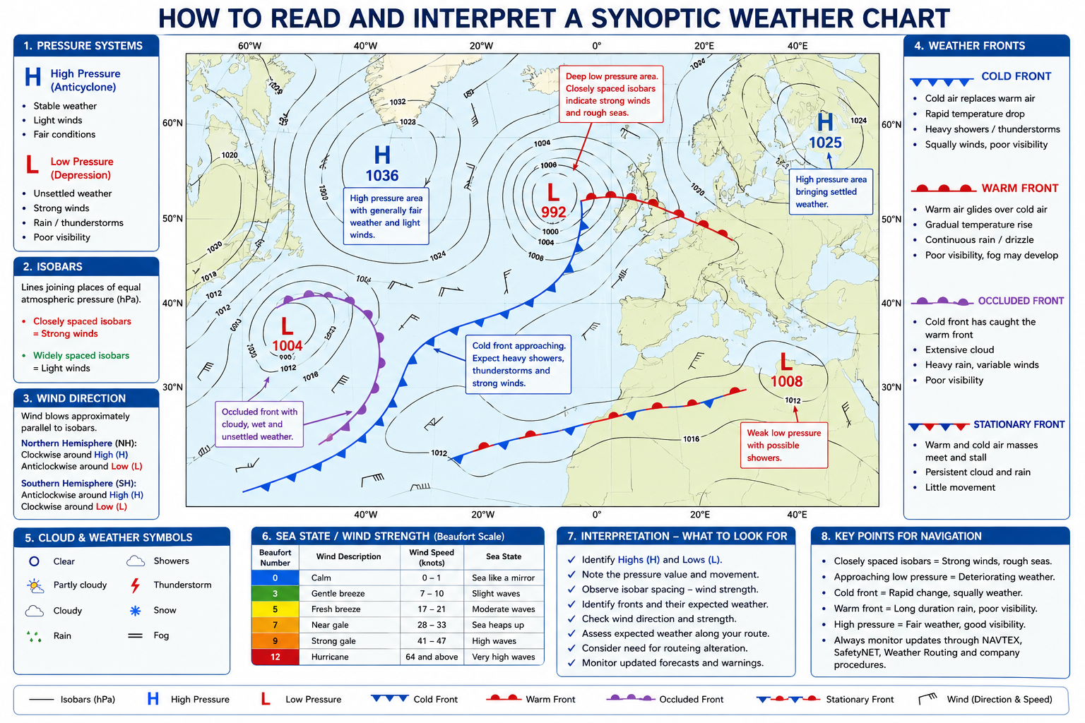
  1. High-pressure systems.
  2. Low-pressure systems.
  3. Isobars.
  4. Warm fronts.
  5. Cold fronts.
  6. Occluded fronts.
  7. Stationary fronts.
  8. Troughs.
  9. Wind direction and expected wind strength.

Chief Mate Synoptic Weather Chart

Common Follow-up Questions

  1. How do closely spaced isobars affect wind strength?
  2. How do you identify an approaching depression?
  3. How would you use a synoptic weather chart during passage planning?
  4. What weather is associated with a cold front and a warm front?

Question 3

What is a Tropical Revolving Storm (TRS)?

A professional answer should include:

  1. Conditions necessary for formation.
  2. Sea surface temperature.
  3. Coriolis force.
  4. Low-pressure development.
  5. Rotation in the Northern and Southern Hemispheres.
  6. Classification of tropical cyclones.

Common Follow-up Questions

  1. Why do tropical cyclones not develop near the Equator?
  2. How would you determine the dangerous semicircle?
  3. What avoiding action would you take?

Question 4

How would you avoid a Tropical Revolving Storm?

Surveyors expect candidates to discuss:

  1. Continuous weather monitoring.
  2. Updating weather forecasts.
  3. Plotting the storm's position and movement.
  4. Altering the planned route early, where necessary.
  5. Maintaining a safe distance from the storm.
  6. Considering the vessel's speed and manoeuvrability.
  7. Following company procedures and weather routing advice.

Question 5

How would you prepare your vessel for heavy weather?

Candidates should include:

  1. Securing cargo.
  2. Securing loose equipment.
  3. Closing all watertight and weathertight openings.
  4. Checking cargo lashings.
  5. Adjusting ballast where required.
  6. Testing steering gear.
  7. Briefing the bridge and engine teams.
  8. Reviewing the passage plan.
  9. Monitoring weather continuously.

Surveyors are looking for a practical and systematic approach rather than a memorised checklist.

Question 6

How would you navigate safely in heavy weather?

A strong answer should include:

  1. Reducing speed where appropriate.
  2. Altering course when necessary.
  3. Avoiding excessive rolling and pitching.
  4. Monitoring hull stresses.
  5. Monitoring cargo condition.
  6. Maintaining effective Bridge Resource Management.
  7. Continuously monitoring weather developments.

Question 7

What is Weather Routing?

Candidates should explain that weather routing aims to determine the safest and most efficient route by considering:

  1. Weather forecasts.
  2. Ocean currents.
  3. Wave heights.
  4. Vessel characteristics.
  5. Fuel efficiency.
  6. Cargo requirements.
  7. Voyage schedule.
  8. Safety considerations.

Question 8

What publications are used for weather forecasting on board?

Possible answers include:

  1. Synoptic Weather Charts.
  2. Weather Routing Services.
  3. NAVAREA Warnings.
  4. NAVTEX.
  5. GMDSS SafetyNET broadcasts.
  6. Admiralty Sailing Directions (for climatic information).
  7. Ocean Passages for the World.
  8. Admiralty Routeing Charts (Pilot Charts).

Question 9

How do ocean currents affect passage planning?

Ocean currents have a direct influence on:

  1. Course Over Ground (COG).
  2. Speed Over Ground (SOG).
  3. Fuel consumption.
  4. Estimated Time of Arrival (ETA).
  5. Weather conditions.
  6. Sea state.
  7. Route selection.
  8. Overall voyage efficiency.

Types of Ocean Currents

Surveyors may ask candidates to classify the different types of ocean currents.

The major types include:

  1. Warm Currents.
  2. Cold Currents.
  3. Surface Currents.
  4. Deep Ocean Currents.
  5. Tidal Currents.
  6. Wind-driven Currents.
  7. Gradient Currents.
  8. Upwelling Currents.
  9. Downwelling Currents.

During the Chief Mate Function 1 Oral Examination, surveyors may also expect candidates to identify the major ocean currents encountered on a proposed voyage, describe their general direction of flow, and explain how they influence passage planning, weather, fuel consumption, Course Over Ground (COG), Speed Over Ground (SOG), and Estimated Time of Arrival (ETA). Candidates should also know how to identify these currents using Ocean Current Charts (Pilot Charts/Routeing Charts) during voyage planning.

Question 10

What precautions would you take before entering an area of sea ice?

A professional answer should include:

  1. Obtain the latest ice charts and ice forecasts.
  2. Monitor NAVAREA Warnings and local navigational warnings.
  3. Reduce speed when appropriate.
  4. Maintain an enhanced lookout.
  5. Optimise Radar settings for ice detection.
  6. Check sea suctions where applicable.
  7. Verify compliance with company procedures and the applicable requirements for the intended voyage.

Common Follow-up Questions

Surveyors frequently continue with questions such as:

  1. What is the difference between wind waves and swell?
  2. How do waves affect ship handling?
  3. What is the Beaufort Scale?
  4. How would you estimate wind force at sea?
  5. What is the difference between a weather warning and a navigational warning?
  6. Which weather information is received through GMDSS?
  7. How do you interpret a synoptic weather chart before commencing a voyage?

Common Mistakes Candidates Make

Many candidates lose marks because they:

  1. Memorise definitions without explaining their practical application.
  2. Confuse weather forecasts with navigational warnings.
  3. Fail to relate meteorology to passage planning.
  4. Ignore the effect of ocean currents on voyage planning.
  5. Give generic heavy weather answers without explaining why particular actions are taken.
  6. Fail to explain how weather information influences navigational decisions.

RCI Exam Tip

Always answer meteorology questions from the perspective of a Chief Mate. Explain how weather information influences passage planning, ship handling, cargo safety and bridge team management. Surveyors expect management-level thinking, where every weather observation leads to a practical navigational decision. Demonstrating this approach will help you score consistently in the Chief Mate Function 1 Oral Examination.
 

ENROLL NOW BY CLICKING HERE


ยฉ 2026 Rashmi Coaching Institute (RCI). All Rights Reserved. This original content is protected by copyright. No part may be copied, reproduced, distributed, translated, or republished without prior written permission from RCI.

โ† Back to Blog

Comments

No comments yet โ€” be the first to share your thoughts.

×
๐Ÿš€ โญ

To do this, create a free account.

Sign up for free access to like posts and join the conversation. As a member, you'll also get our weekly newsletter and a personalised experience.

JOIN OUR COMMUNITY